
Demarcation and Boundary Surveys
Are you involved in land development, property sales, or legal disputes? Understanding the exact boundaries of your land is non-negotiable. Our Demarcation and Boundary Survey services at Geo Static Survey Engineering are designed to give you the clarity and confidence you need.
Let us help you avoid costly mistakes and future legal complications. Trust Geo Static for all your demarcation and boundary survey needs.
What Do Demarcation and Boundary Surveys Include?
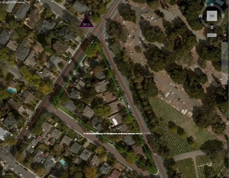
Demarcation and boundary surveys are designed to determine and mark the precise legal boundaries of a property. These surveys are essential for legal documentation, dispute resolution, and property development.
Here’s what you can expect from our demarcation and boundary surveys:
- Land Boundary Identification: We accurately identify your land’s borders based on historical records, legal documents, and physical land features.
- Fencing & Boundary Marking: Whether it’s for residential, commercial, or rural properties, we provide clear boundary markers for fences, walls, or signage.
- Legal Documentation: We create official, legally recognised boundary maps that can be used for property disputes, sales, and development projects.
- Subdivision and Land Development Support: Our surveys provide the necessary information for dividing land into smaller parcels or for large-scale land developments.
By knowing the exact boundaries of your property, you can avoid costly disputes and ensure your land is used to its full potential.
Our Demarcation and Boundary Surveys Servicse
At Geo Static, we offer a range of services tailored to your specific needs, all designed to ensure that your property boundaries are clearly defined and legally recognised:
- Property Boundary Surveying: Whether you’re buying or selling, we provide precise surveys that mark your property’s exact limits. Our surveys ensure that your property documentation is legally binding and accurate.
- Boundary Dispute Resolution: If you’re dealing with a boundary dispute, our surveys offer the evidence you need. Our experts work with legal teams to provide professional testimony and support.
- Land Subdivision Surveys: Planning to split a property into smaller parcels? Our subdivision surveys provide accurate measurements and boundary placements to ensure compliance with local regulations.
- Land Development Surveys: For any land development project, we offer boundary surveys to help you maximise land use, whether it’s for residential, commercial, or industrial developments.
- Fencing & Boundary Marking: We provide permanent boundary markers for your property, making it clear where your land begins and ends.
With our state-of-the-art technology and skilled surveyors, we offer timely and precise results to ensure you have the information you need to move forward with your project.

Why Choose Geo Static for Demarcation and Boundary Surveys?
Here’s why so many trust Geo Static Survey Engineering for their demarcation and boundary survey needs:
- Expertise You Can Rely On: With years of experience, our team knows exactly how to handle all types of property surveys. From residential plots to large commercial properties, we’ve got the expertise to deliver results.
- Cutting-Edge Surveying Technology: We use advanced technology, including GPS, Total Station, and high-resolution imaging to ensure accurate boundary identification.
- Timely Results: We understand the importance of time in property projects. That’s why we guarantee quick turnaround times without compromising accuracy.
- Transparent Pricing: At Geo Static, there are no hidden fees. You’ll get upfront pricing and clear, transparent cost breakdowns so you know exactly what you’re paying for.
When you choose Geo Static, you get a team that is committed to providing you with reliable, accurate, and legally recognised boundary surveys.
Getting Started with GEO Static for Demarcation and Boundary Surveys
Need to define the exact boundaries of your property? Contact Geo Static Survey Engineering today for reliable and accurate demarcation and boundary survey services.
Get in touch with our expert team now to schedule your consultation and start your project on the right foot. We’re here to ensure your land is clearly defined and legally protected.
Call us at +880 1602060802 or email info@geostaticbd.com to speak with one of our experts today.
The Geo Static Demarcation and Boundary Surveys Process
Our process is straightforward, efficient, and designed to provide you with the results you need quickly:
- Consultation
First, we discuss your project and specific requirements. Whether it’s for land subdivision, property sale, or dispute resolution, we’ll understand your needs to provide the best solution.
- Site Assessment
Our team conducts a thorough on-site assessment of your land, considering historical data, legal documents, and any physical markers or features on the property.
- Surveying
Using the latest surveying equipment, we measure and mark the exact boundaries of your property. Our equipment ensures high accuracy and reliable results.
- Delivery of Results
You’ll receive your survey results on time, giving you all the information you need to proceed with your project or resolve any boundary issues.
Our streamlined process ensures you get fast, reliable, and precise results every time.
FAQs
Q: What is a demarcation and boundary survey?
A: A demarcation and boundary survey identifies and marks the precise legal boundaries of a property, using historical records, physical landmarks, and modern surveying equipment.
Q: How accurate are boundary surveys?
A: Our surveys are highly accurate, often pinpointing property boundaries within millimetres, ensuring that your land is clearly defined.
Q: Can boundary surveys help resolve disputes?
A: Yes, our surveys provide legally recognised evidence that can help resolve boundary disputes between property owners or neighbouring lands.
Q: How long does a boundary survey take?
A: The length of time varies depending on the size of the property and the complexity of the survey. However, we pride ourselves on delivering results quickly and efficiently.
Our Process