
Real-Time Kinematic (RTK) Survey
At GEO Static, we bring the power of centimetre-level accuracy to your mapping and surveying needs.
Our Real-Time Kinematic (RTK) survey services deliver precise, real-time data for construction, agriculture, and urban planning projects.
Experience the difference that pinpoint accuracy can make in your operations.
What Does Real-Time Kinematic (RTK) Survey Include?
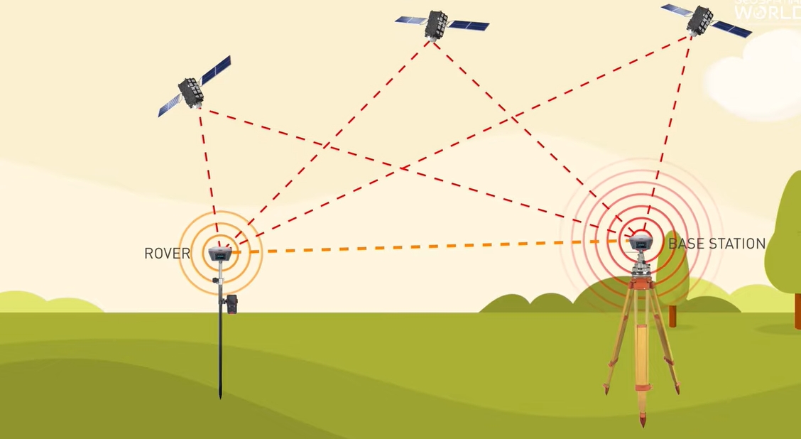
RTK is all about delivering pinpoint accuracy, with real-time GPS/GNSS corrections. What makes it stand out is that RTK utilises a base station that communicates directly with a rover, correcting the satellite signals in real-time.
This process helps reduce common errors that occur due to atmospheric conditions or satellite signal delays, giving you results with an accuracy level down to centimetres!
RTK surveys involve:
- The precision that’ll make your head spin: We’re talking accuracy down to a few centimetres. That’s like being able to measure the length of an ant’s antenna!
- Speedy results: No more waiting around. Get your data faster than a pizza delivery.
- Coverage that goes the distance: We’ll map your area quickly, whether it’s a backyard or a sprawling farm.
- Fits like a glove: From bustling city streets to remote forests, our tech works everywhere you need it.
- A helping hand: Our friendly experts are always ready to guide you, like a GPS for the GPS!
With GEO Static’s RTK survey, you’re not just getting a service – you’re getting a game-changer for your projects. Ready to see the world in high definition?
Our Real-Time Kinematic (RTK) Survey Services
At GEO Static, our Real-Time Kinematic (RTK) survey services are designed to meet the high-precision demands of various industries.
With state-of-the-art equipment and experienced professionals, we deliver surveys that ensure accurate data, allowing you to make informed decisions for your projects. Here’s how we can help:
- Precision Land Surveying: Whether you’re involved in property development or land subdivision, our RTK services provide unparalleled accuracy in mapping terrain and determining boundary lines. With centimetre-level precision, our surveys reduce errors and disputes, ensuring that your land development projects proceed smoothly.
- Construction Layouts and Site Planning: In construction, every centimetre counts. Our RTK surveys ensure the exact placement of foundations, road alignments, utility lines, and other crucial infrastructure. This level of precision eliminates costly rework and ensures that structures are built to the highest standards from the ground up.
- Infrastructure and Civil Engineering Projects: For large-scale infrastructure projects like bridges, highways, tunnels, and pipelines, precision is key. RTK surveys from GEO Static ensure that all measurements are correct from the start, reducing the risk of delays and cost overruns. With real-time data, we help you stay on schedule and within budget.
- Agricultural and Environmental Applications: In precision agriculture, RTK is used for tasks like planting, irrigation planning, and crop monitoring. Farmers can track the performance of their crops down to the exact row, maximising yield and resource efficiency. In environmental monitoring, RTK aids in tracking changes in land use, erosion patterns, and other natural shifts, offering a reliable tool for sustainability efforts.
- Topographical and Geospatial Mapping: When it comes to topography and geospatial data collection, RTK surveys are essential for creating detailed and accurate maps. From contour mapping to 3D terrain models, our services provide the high-resolution data you need to support everything from urban planning to mining operations.
- Marine and Coastal Surveys: Our RTK systems are also applied in marine environments for tasks like shoreline mapping, dredging, and underwater construction projects. The enhanced accuracy offered by RTK ensures that even in dynamic marine conditions, you get the data you need to make informed decisions.
With GEO Static’s RTK survey services, you’re not just getting accurate data—you’re gaining a trusted partner committed to the success of your project. Whether your needs are on land or at sea, our team is here to support you with fast, reliable results.

Why Choose GEO Static for Your Real-Time Kinematic (RTK) Survey?
When it comes to accurate and efficient land surveying, choosing the right partner is critical to the success of your project. At GEO Static, we bring a unique combination of expertise, technology, and a customer-focused approach that sets us apart from the competition.
- Industry Expertise: With years of experience in RTK surveying across diverse industries, our team ensures that your project gets the attention it deserves. From construction to environmental studies, we know how to handle the specific demands of different sectors.
- High-Precision Accuracy: We understand that accuracy is key. That’s why we utilise the latest RTK technology, delivering results with centimetre-level precision. Our focus on data integrity helps minimise errors and keeps your project on track.
- Cost-Effective Solutions: At GEO Static, we believe quality doesn’t have to come at a steep price. Our services are designed to be both high-quality and affordable, giving you the best of both worlds without breaking the bank.
- Client-Focused Service: We value strong partnerships. We take the time to understand your project’s specific needs and tailor our services to meet them. No matter the size or complexity of your project, our dedicated team is here to support you every step of the way.
- Proven Results: Don’t just take our word for it—our long list of satisfied clients can testify to the positive impact our RTK services have made on their projects. We’re confident we can help you achieve the same success.
Choosing GEO Static means choosing a partner that’s committed to delivering precision, reliability, and top-notch service, all while keeping your budget in mind. Let’s get started on your next project today!
Getting Started with GEO Static for Real-Time Kinematic (RTK) Surveying
If precision is paramount for your project, Geo Static’s Real-Time Kinematic (RTK) Surveying service offers the highest level of accuracy available. Whether you’re working on construction, mapping, or any other project that requires real-time data collection, our RTK technology provides instant, reliable results, ensuring your work is always on point.
Our team of experts is here to guide you through the RTK surveying process. We’ll work closely with you to deliver accurate positioning data that meets your project’s needs, all while keeping everything efficient and on schedule.
For quotes, queries, or expert advice, don’t hesitate to reach out. You can give us a call at +880 1602060802, send an email to info@geostaticbd.com, or simply complete our online form. We’ll take care of the details and provide the support you need every step of the way.
The Geo Static Real-Time Kinematic (RTK) Survey Process
At GEO Static, we’ve fine-tuned our RTK survey process to ensure it’s as efficient and hassle-free as possible while delivering precise and reliable results. Here’s how we handle each stage:
- Consultation
We start by discussing your project requirements, including location, scope, and any specific challenges. This allows us to create a customised plan and provide a clear, upfront quote. No surprises—just transparency from the start.
- On-Site Survey
Our skilled surveyors arrive on-site equipped with cutting-edge RTK technology. After setting up a base station, we collect data using rovers. This process ensures real-time accuracy as we track precise coordinates, no matter the terrain.
- Data Analysis
During the survey, data corrections are applied instantly, allowing us to capture information with centimetre-level accuracy. This real-time processing eliminates delays and errors, ensuring you get the most accurate results right away.
- Delivery
After the fieldwork is done, we thoroughly review the collected data and create a detailed report. This includes maps, coordinates, and other relevant information, presented in a format that’s easy to understand and use.
By following this refined process, GEO Static guarantees precise data, fast turnaround times, and ongoing support to keep your project moving smoothly.
FAQs
Q: How accurate is an RTK survey?
A: RTK surveys are known for their high precision, often accurate to within a few centimetres. This makes them ideal for projects where even small errors could have big consequences.
Q: How long does an RTK survey take?
A: The time required for an RTK survey depends on the size and complexity of the site. However, because data is processed in real-time, RTK surveys are usually quicker than traditional methods.
Q: What industries benefit from RTK surveys?
A: RTK surveys are commonly used in construction, land development, agriculture, environmental monitoring, and infrastructure projects.
Q: Can GEO Static handle large-scale projects?
A: Absolutely! We’ve got the expertise and equipment to take on projects of any size, from small land plots to large-scale infrastructure projects.
Our Process