
Plot Survey
When you’re dealing with property ownership, construction, or land development, understanding the exact boundaries of your plot is crucial. That’s where plot surveys come in handy.
At GEO Static, we provide accurate, timely, and affordable plot survey services to make sure you’re standing on solid ground—literally and legally.
What Does a Plot Survey Include?
A plot survey is an essential tool for anyone dealing with property. It’s not just about marking the edges of your land; it’s a comprehensive process that provides vital information. Here’s what you can expect from a plot survey:
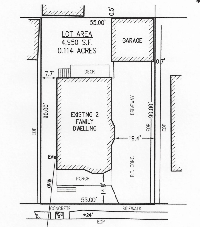
- Boundary Measurements: First and foremost, a plot survey accurately identifies your property lines and corners. This ensures you know exactly where your land begins and ends, preventing any confusion or disputes with neighbours.
- Identifying Easements: An important aspect of property ownership is understanding easements—these are legal rights that allow others to use a portion of your land for specific purposes, like accessing utilities. A plot survey maps out these easements, helping you know who can access your land and why.
- Existing Structures: The survey will pinpoint all existing structures on your property, such as buildings, fences, and driveways. This information is crucial if you plan on making renovations or adding new structures, ensuring that everything is compliant with local regulations.
- Topographical Features: Our surveys also document natural features on your plot. This includes slopes, trees, water bodies, and other elements that could influence your development plans. Understanding the topography is vital for planning drainage, landscaping, and construction.
With this essential data, a plot survey not only defines the legal boundaries of your property but also helps avoid any unwanted surprises down the line, like accidentally building on someone else’s land or violating zoning regulations.
Our Plot Survey Services
At GEO Static, we’re dedicated to providing a wide range of plot survey services tailored to meet your specific needs. Here’s what we offer:
- Boundary Surveying: Knowing your property’s legal boundaries is crucial. Our team uses advanced technology to accurately identify and mark the corners and edges of your land. This service helps you avoid disputes and ensures you’re building or renovating within your rightful limits.
- Topographical Surveys: Perfect for developers and construction projects, our topographical surveys provide detailed maps of your land’s elevation, slopes, and significant natural features. This data is vital for planning drainage, grading, and ensuring compliance with local regulations.
- Subdivision Surveys: Planning to divide your land? We can help! Our subdivision surveys meticulously map out individual plots for development or sale, ensuring you meet all local zoning laws and requirements. This service streamlines the process for real estate agents and developers alike.
- Construction Staking: If you’re ready to break ground, our construction staking service is just what you need. We accurately mark the locations for your structures, giving contractors clear guidelines to follow. This helps keep your project on track and ensures everything is built exactly where it should be.
Whether you’re a homeowner looking to understand your property better, a builder needing precise data for construction, or a land developer planning new projects, our plot survey services are designed with you in mind.

Why Choose Geo Static for Plot Survey?
At GEO Static, we understand that clarity in land measurement sets the foundation for successful projects. Here’s why we’re the go-to choice for your plot survey needs:
- Expertise Across Industries: Our team has vast experience in conducting plot surveys across various sectors. We understand the unique challenges that come with each project and are prepared to handle them efficiently, ensuring a smooth process from start to finish.
- State-of-the-art technology: We use the latest GPS, RTK, and laser scanning technology to guarantee the most precise results. With GEO Static, you can trust that your plot survey is backed by the best technology available, ensuring unmatched accuracy.
- Affordable Solutions: We believe that high-quality services shouldn’t break the bank. At GEO Static, we offer competitive pricing without sacrificing quality, making top-notch surveying accessible for everyone.
- Client-Focused Service: We take the time to understand your specific needs and are here to support you throughout the entire process. Whether it’s a small residential plot or a large-scale development, we treat every project with the same level of dedication and care.
- Proven Results: Our long list of satisfied clients speaks volumes. We’ve successfully helped homeowners, builders, and developers complete their projects without the stress of boundary uncertainties, allowing them to focus on what matters most.
Ready to take the next step in your project? Contact GEO Static today to discuss your plot survey needs. Our team is here to provide you with the clarity and accuracy you need to move forward confidently!
Getting Started with GEO Static for Plot Surveys
If you’re planning to buy, sell, or develop land, accurate Plot Survey data is essential. At Geo Static, we specialise in providing precise Plot Surveys that give you a clear understanding of land boundaries, topography, and other important features. With our expertise, you can move forward with confidence, knowing your project or transaction is built on solid, trustworthy information.
Whether you’re looking for a detailed plot survey, have questions about the process, or need professional advice, our team is here to help. We’re dedicated to delivering accurate, reliable results and offering ongoing support to ensure your land-related decisions are based on the most current data.
Reach out to us today by calling +880 1602060802, emailing info@geostaticbd.com, or filling out our online form. We’ll take care of the rest, ensuring you have everything you need to proceed smoothly with your plot-related plans.
The Geo Static Plot Survey Process
When you choose GEO Static for your plot survey, you can expect a seamless and efficient process designed with your needs in mind. Here’s how we make it happen:
- Consultation
We begin by discussing your project details and requirements. Understanding your needs allows us to provide a clear and transparent quote, so you know exactly what to expect.
- On-Site Survey
Our skilled team arrives at your property, equipped with advanced surveying tools. We set up quickly and started the data collection process, working efficiently to avoid delays and respect your time.
- Data Analysis
As we collect the data, it is processed in real-time. This allows us to make adjustments as needed, ensuring accuracy throughout the survey.
- Delivery
Once the survey is complete, we compile all the data into a detailed, easy-to-read report. This includes maps, boundaries, and any other critical information you need to move forward confidently.
Our structured process ensures that you’re in the loop from start to finish, with timely delivery and uncompromised quality. Contact us today to schedule your consultation and discover how we can help you achieve clarity and peace of mind with your land.
FAQs
Q: What is the purpose of a plot survey?
A: A plot survey determines the exact boundaries and features of a piece of land. It helps prevent boundary disputes and ensures any construction complies with local zoning laws.
Q: How does a plot survey benefit property development?
A: A plot survey provides accurate measurements and details necessary for planning and development. It helps developers make informed decisions and avoid costly mistakes during construction.
Q: What information will I receive from a plot survey?
A: You’ll receive a detailed report that includes maps, property boundaries, elevation data, and any existing easements or encroachments on the land.
Q: How long does a plot survey usually take?
A: The duration depends on the size and complexity of the property. Typically, surveys can be completed within a few days, depending on the accessibility and conditions of the site.
Q: What is the average cost of a plot survey in BDT?
A: The cost can vary significantly based on location and complexity, generally ranging from BDT 10,000 to BDT 50,000. It’s advisable to get quotes from different surveyors for a precise estimate.
Our Process