
Oceanographic Survey
Expert Oceanographic Survey for Marine Research and Management
Are you interested in exploring the wonders of the ocean? Oceanographic surveys are your gateway to understanding the complexities of marine environments. These surveys collect vital data on both the physical and biological characteristics of our seas.
Whether you’re involved in research, environmental monitoring, or resource management, grasping the intricacies of our oceans is essential.
At Geo Static, we provide thorough oceanographic surveys that equip you with the insights needed to make well-informed decisions regarding marine activities.
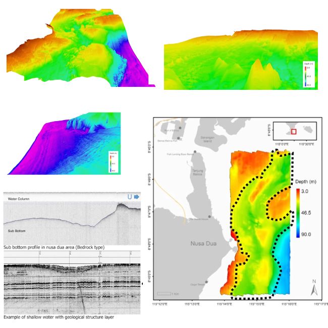
What Does a Oceanographic Survey Include?
Oceanographic surveys are like exciting quests for essential data about our oceans. Here’s what these surveys typically include:
- Water Quality Assessments: We measure important factors such as temperature, salinity, pH, and nutrient levels. This data is crucial for evaluating the health of marine ecosystems.
- Seafloor Mapping: Using cutting-edge technology, we create detailed maps of the ocean floor. These maps uncover features like underwater ridges, valleys, and various habitats, giving you a clear picture of the seafloor’s landscape.
- Biological Surveys: Our team studies marine life, including fish populations and coral reefs, to assess biodiversity and the overall health of these vital ecosystems.
- Current and Wave Measurements: By tracking ocean currents and wave patterns, we provide insights that are essential for navigation, fishing, and coastal management.
Oceanographic surveys are vital for scientists, environmentalists, and anyone who cares about the health of our oceans. They provide the knowledge needed to make informed decisions and protect our marine environments.
Our Oceanographic Survey Services
At Geo Static, our oceanographic survey services are designed to provide you with essential insights into marine environments. Here’s what we offer:
- Water Quality Monitoring: We assess various parameters like temperature, salinity, pH, and nutrient levels to evaluate the health of marine ecosystems. This data is crucial for understanding how changes in the environment can affect marine life.
- Seafloor Mapping: Using advanced sonar and imaging technology, we create detailed maps of the ocean floor. This includes identifying underwater features such as ridges, valleys, and habitats that are vital for marine navigation and habitat conservation.
- Biological Assessments: We conduct surveys of marine life, including fish populations and coral reefs. Our studies focus on biodiversity, ecosystem health, and the impact of human activities on these vital resources.
- Current and Wave Measurements: By measuring ocean currents and wave patterns, we help in understanding their effects on coastal management, navigation, and fishing practices.
- Sediment Sampling and Analysis: We collect and analyze sediment samples to study their composition and the effects of sediment transport on marine ecosystems.
At Geo Static, we harness state-of-the-art technology and proven methodologies to deliver precise and actionable insights, supporting your marine projects and environmental initiatives.
Why Choose Geo Static for Oceanographic Survey?
Selecting the right partner for your oceanographic surveys is essential for success. Here’s why Geo Static is the ideal choice:
- Experienced Professionals: Our team comprises seasoned experts in marine science and surveying. With their extensive knowledge, you can trust us to deliver top-notch results every time.
- Advanced Technology: We harness the latest equipment and techniques to gather precise data efficiently. This means you get reliable information without unnecessary delays.
- Tailored Solutions: Every project is unique, and we recognise that. We work closely with you to customize a survey that perfectly fits your specific requirements and objectives.
- Commitment to Sustainability: We care deeply about the marine environment. Our surveys are conducted with a strong focus on sustainable practices, ensuring we protect the oceans while gathering critical data.
Choose Geo Static for your oceanographic surveys and experience the difference that expertise, technology, and dedication can make!
Getting Started with GEO Static for Oceanographic Survey
Are you ready to dive into the fascinating world of oceanographic surveys? At Geo Static, we’re here to help you uncover the mysteries of our oceans. Whether you need thorough environmental assessments, precise seafloor mapping, or biological surveys, our dedicated team is ready to support you every step of the way.
If you’re seeking a free quote, have questions about our services, or need expert guidance, don’t hesitate to reach out. We’re committed to providing you with accurate and timely data, ensuring your project is a success from the very beginning.
You can call us at +880 1602060802, email us at info@geostaticbd.com, or fill out our online form. We’re here to assist you, making sure you receive the support you need, exactly when you need it.
At Geo Static, we’re passionate about helping you explore the depths of our oceans with confidence and ease.
The Geo Static Oceanographic Survey Process
At Geo Static, we’ve developed a straightforward and effective process for conducting oceanographic surveys. Here’s how we do it:
- Consultation
We start by chatting with you to understand your goals and specific needs. This helps us customize our approach to suit your project perfectly.
- Survey Planning
Our experienced team crafts a detailed survey plan, choosing the most suitable methodologies and equipment to get the job done right.
- Data Collection
Using state-of-the-art tools, we gather vital information about water quality, marine life, and the characteristics of the seafloor.
- Detailed Reporting
Our experts dive deep into the data, providing you with comprehensive reports that highlight essential findings and insights, making the information easy to understand.
With our structured process, you can trust that your oceanographic survey will be thorough and tailored to your needs, giving you the information necessary to make informed decisions.
FAQs
Q: What is an oceanographic survey?
A: An oceanographic survey is a scientific study that collects data about the physical, chemical, biological, and geological aspects of the ocean. This helps us understand ocean conditions, marine life, and the overall health of marine ecosystems.
Q: What is the instrument for oceanographic survey?
A: Oceanographic surveys use a variety of instruments, including CTD sensors (conductivity, temperature, depth), sonar systems for mapping the seafloor, and water sampling devices. These tools help gather crucial data about ocean conditions.
Q: What is the importance of oceanographic research?
A: Oceanographic research is vital for understanding climate change, managing fisheries, protecting marine environments, and ensuring safe navigation. It provides insights that guide conservation efforts and inform policy decisions.
Q: What are the oceanographic measurements?
A: Oceanographic measurements include parameters such as temperature, salinity, pH, dissolved oxygen, nutrient levels, and current speed. These metrics help assess the health and dynamics of marine ecosystems.
Q: What are some examples of oceanographic tools?
A: Some examples of oceanographic tools include remotely operated vehicles (ROVs), autonomous underwater vehicles (AUVs), buoys for monitoring weather conditions, and sediment cores for collecting seafloor samples. These tools enhance our ability to study the ocean.
Our Process