
Plot Survey
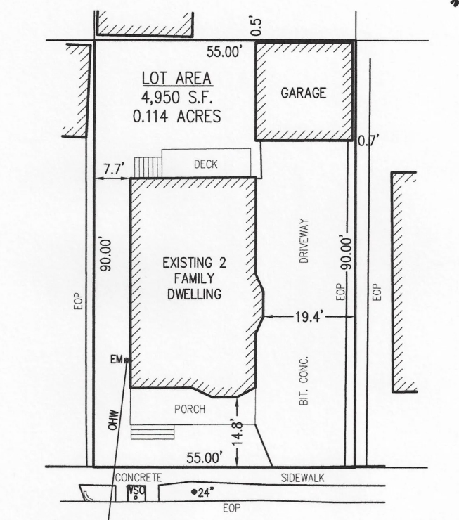
Plot Survey When you’re dealing with property ownership, construction, or land development, understanding the exact boundaries of your plot is crucial. That’s where plot surveys come in handy. At GEO Static, we provide accurate, timely, and affordable plot survey services to make sure you’re standing on solid ground—literally and legally. What Does a Plot Survey […]
Real-Time Kinematic (RTK) Survey
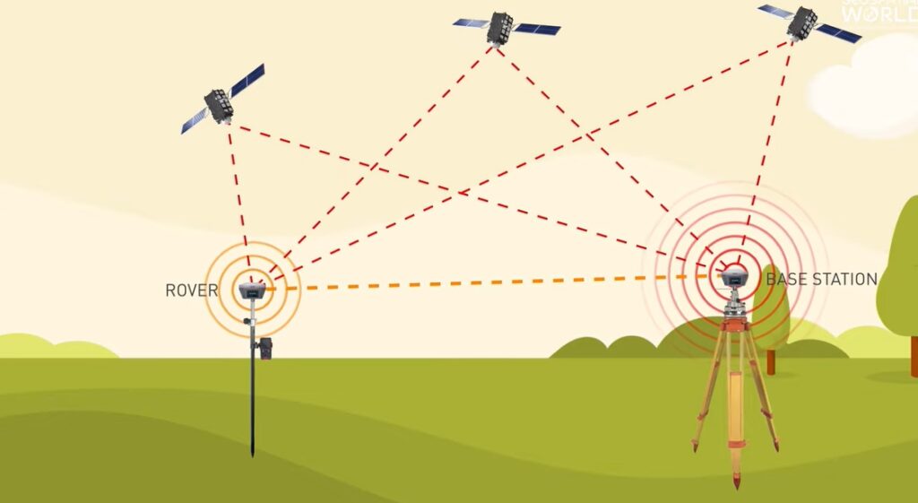
Real-Time Kinematic (RTK) Survey At GEO Static, we bring the power of centimetre-level accuracy to your mapping and surveying needs. Our Real-Time Kinematic (RTK) survey services deliver precise, real-time data for construction, agriculture, and urban planning projects. Experience the difference that pinpoint accuracy can make in your operations. What Does Real-Time Kinematic (RTK) Survey Include? […]
Master Plan Survey

Master Plan Survey A master plan survey isn’t just a survey; it’s the foundation for project success. Whether starting on a new development or preparing for a major expansion, understanding every inch of your land saves you from unexpected setbacks. At GEO Static, our master plan surveys are here to turn your vision into a […]
Underground Utility Surveys

Underground Utility Surveys Expert Underground Utility Surveys for Safe Construction and Planning Starting a construction project? Whether building a house, laying down new roads, or upgrading infrastructure, what’s hidden underground can be a game-changer. Hitting a pipe or cable you didn’t know was there can cause big headaches—costly delays, unexpected expenses, or even safety risks. […]
As-Built Surveys
As-Built Surveys Expert As-Built Surveys for Accurate Project Documentation Are you in the construction industry? If so, you understand the importance of staying on top of every detail during a project. That’s where As-Built Surveys come in. These surveys provide a clear picture of what has been built compared to the original plans. They reveal […]
Contour Surveys

Contour Surveys Expert Contour Survey Services for Planning and Construction When you’re planning to build or develop land, getting a clear picture of your site is the first crucial step. That’s where a contour survey comes in. This type of survey helps you understand the natural shape of your land, showing how the ground slopes […]
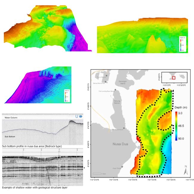
Bathymetric Surveys

Bathymetric Surveys Elevate Your Hydrographic Data: Next-Gen Bathymetric Surveys by GEO Static If you’re working on a project that involves water, whether it’s construction, navigation, or environmental research, knowing what’s beneath the surface is crucial. That’s where bathymetric surveys come in. These surveys map the underwater landscape, giving you detailed data on the depth and […]
Land Surveyor in Dhaka Bangladesh

Land Surveyor in Dhaka Bangladesh Geo Static Survey Engineering & Consultants: Your Trusted Partner for Accurate Land Surveying in Bangladesh. Let’s Talk Top Land Surveying Services in Bangladesh Looking for the best land surveyor in Bangladesh? GEO Static Survey Engineering and Consultants could be the suitable option for you. As the most trustworthy survey company […]
Oceanographic Survey
Oceanographic Survey Expert Oceanographic Survey for Marine Research and Management Are you interested in exploring the wonders of the ocean? Oceanographic surveys are your gateway to understanding the complexities of marine environments. These surveys collect vital data on both the physical and biological characteristics of our seas. Whether you’re involved in research, environmental monitoring, or […]
Topographic Surveys

Topographic Surveys Expert Topographic Surveys for Construction, Planning, and Development Planning a development, or even just managing land, is much easier when you know exactly what you’re working with. That’s where a topographic survey comes in. A topographic survey provides detailed information about the natural and man-made features of a piece of land, helping you […]