Our Projects
- Home
- Projects
Geo Static Survey Engineering & Consultants - Our Valued Projects
Geo Static Survey Engineering & Consultants is a trusted name in the field of land surveying and consultation services in Bangladesh.
Over the years, we have proudly contributed to various projects across multiple sectors, providing comprehensive surveying solutions, including topographic surveys, land demarcation, bathymetric surveys, feasibility studies, consultancy, building design, RAJUK plan approval and more.
Below, we provide detailed insights into some of our prominent projects that reflect our expertise and commitment to delivering high-quality services.
Survey of Electric Poles with Consumer Location and Physical Features for Madhabdi Pourashava of Narshingdi-1 and City Corporation Area
Client: Development Design Consultants Ltd.
Conducted an extensive survey for Bangladesh Rural Electrification Board (BREB), mapping electric poles, consumer locations, and the physical features of the area to improve the electrical distribution system in Madhabdi Pourashava and Gazipur PBS-2.
Topographic Survey for Master Plan of Galachipa Upazila Complex Area
Client: Development Design Consultants Ltd.
Performed a detailed topographic survey for the Galachipa Upazila in Patuakhali to assist in the creation of a master plan for future infrastructural development in the region.
Topographic Survey for Land Acquisition Plan of Hasara-Alampur-Shibrampur-Kharsur Road (Z-8003)
Client: Roads and Highways Department (RHD), Munshiganj, Dhaka
Conducted a topographic survey to facilitate the land acquisition process for road expansion in Munshiganj, aimed at improving infrastructure and accessibility.
Topographic Survey with Bathymetric Survey for River Bank Protection Work Along The Right Bank of Dhaki River, Pasur River, Khulna
Client: MM Builders & Engineer’s Ltd.
Provided surveying services for the river bank protection project along the Dhaki and Pasur rivers in Khulna, focusing on flood control and preventing soil erosion.
Digital Topographical Survey for Land Demarcation and Volumetric Analysis
Client: Citymead Real Estate & Development Ltd.
Conducted a digital topographical survey to assist Citymead Real Estate in land demarcation and volumetric analysis, which provided crucial data for construction and property development.
Digital Topographic Survey for Water Preservation and Safe Water Supply Project
Client: Department of Public Health Engineering (DPHE)
Conducted digital topographic surveys across multiple districts for DPHE’s initiative to maintain safe water supply systems, aiding in water preservation projects.
Digital Topographical Survey for Land Demarcation and Volumetric Analysis of OMC Rupganj Project
Client: Overseas Marketing Corporation (OMC)
Conducted a comprehensive digital topographic survey for the Rupganj project, focusing on land demarcation and volumetric analysis for site development and construction.
Digital Topographic Survey for Road Project in Dhaka
Client: Centre for Advisory and Testing Services (CATS-MIST)
Completed a digital topographic survey for the 11.44 km-long road project in Dhaka, crucial for the city’s infrastructural development.
River Bathymetry Survey for the 4-River Project
Client: Ahad Builders
Conducted a bathymetric survey across 200 kilometers of the Bangali River from Shahjadpur to Trimohoni Bridge in Gaibandha, aiding river rehabilitation for the Bangladesh Water Development Board.
Digital Topographical Survey for Chadpura Mouza
Client: Local Government Engineering Department (LGED), Galachipa, Patuakhali
Performed a digital topographical survey for Chadpura Mouza in the Paschim Dakkhin Modhupura area, assisting local infrastructural planning and development.
Bathymetric Survey of Shakbaria River, Khulna
Client: Future Infrastructure Development Ltd.
Conducted a bathymetric survey in Koyra, Khulna, specifically in the Shakbaria River to understand river dynamics and support future flood control measures.
Topographic Survey for Inlet Construction in Polder No-14/1
Client: Khulna W.D Division, BWDB, Khulna
Contributed to the construction of 13 inlets in Polder No-14/1, aimed at improving flood control and water management systems in Khulna District.
Bathymetric Survey for Shakbaria River
Client: Matin Construction
Conducted a bathymetric survey in the Shakbaria River to improve waterway navigation and flood management in the Khulna region.
Topographic Survey for Drainage Re-excavation in Polder No-14/1
Client: Khulna W.D Division, BWDB, Khulna
Performed a detailed survey for the re-excavation of four drainage khals in Polder No-14/1 as part of efforts to restore drainage systems and manage water flow effectively in Khulna.
Topographical & River Bathymetry Survey for Koyra, Khulna
Client: Amin & Co.
Conducted topographical and river bathymetry surveys in the Koyra area to support construction and flood prevention projects.
Sub-soil Investigation for Inlet Construction in Polder No-14/1
Client: Khulna W.D Division, BWDB, Khulna
Carried out essential sub-soil investigations for inlet construction in Polder No-14/1, providing data necessary for design preparations and flood control measures.
Sub-soil Investigation for Regulator Construction
Client: Khulna W.D Division, BWDB, Khulna
Conducted sub-soil investigations for the construction of regulators in Polder No-14/1, supporting the preparation of design data for controlling water flow.
Topographic Survey for Regulator Construction in Polder No-14/1
Client: Khulna W.D Division, BWDB, Khulna
Conducted topographic surveys for the construction of two critical regulators in Padmapukur and Jorshing, essential for flood control and irrigation purposes.
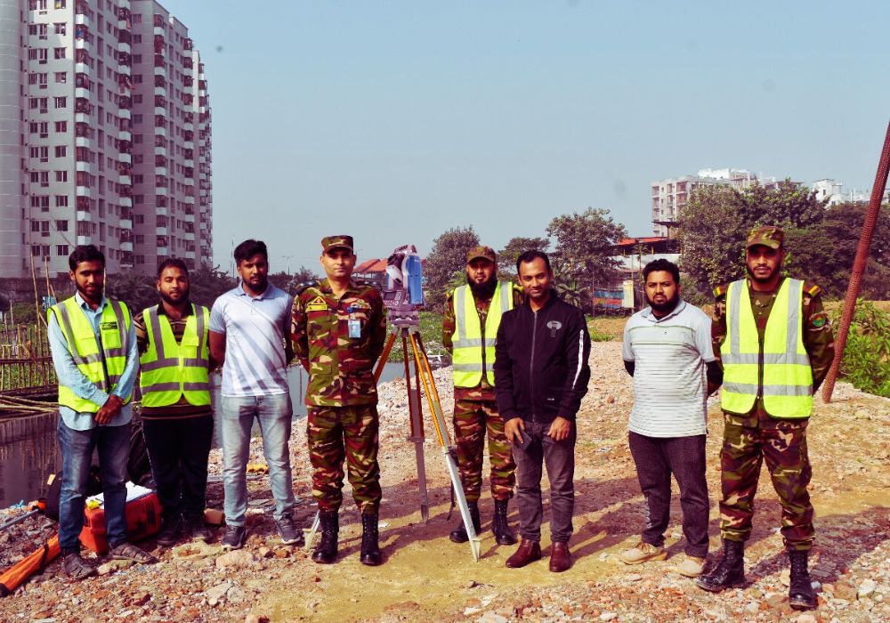
Survey for Feasibility Study of Airport Alternative Link Road Construction
Client: 16 ECB (Engineer Construction Battalion), Bangladesh Army
Supported the feasibility study for the construction of an alternative link road to the airport in Dhaka, providing vital data for planning and execution.
Survey for Polder No-14/1 Rehabilitation
Client: Khulna W.D Division, BWDB, Khulna
Conducted detailed surveys for the rehabilitation project of Polder No-14/1, assessing infrastructure and providing data for flood prevention and drainage management.
Feasibility Study Survey for Airport Link Road
Client: 16 ECB (Engineer Construction Battalion), Bangladesh Army
Performed an in-depth survey for the feasibility study of an airport link road, ensuring the project could proceed with minimal environmental and infrastructural impacts.
At Geo Static Survey Engineering & Consultants, we are dedicated to delivering precise and high-quality surveying services. With years of experience working with a diverse range of clients across the country, we pride ourselves on our ability to cater to the unique requirements of each project. Whether it’s topographic, bathymetric, or digital surveys, we ensure every project is executed with the highest level of professionalism, accuracy, and efficiency.
We are proud to be enlisted with The Survey of Bangladesh (SOB), the national mapping authority of Bangladesh under the Ministry of Defence. Being registered with SOB affirms our adherence to the highest standards of survey practices and regulations in the country. This further underscores our commitment to providing reliable, accurate, and professional surveying services to our clients.